I signaled the two junior members of the patrol, Al and Andy, to pull security while Jim and I lay on the ground behind our rucks, close to the southern edge of our RON.
“Jim, I said quietly, show me today’s route.”.
Jim pulled out his map case, opened it and studied the map under the clear plastic cover for a few minutes. Then, looking around into the thick fog enveloping us, he struggled to get his bearings from the terrain around us in order to orient the map. Finally he gave up due to the poor visibility, he just couldn’t make out any of the terrain features. He took his primary compass from the same case and after opening the top, he placed it on the map with one edge of the compass lined up with the maps north-south grid lines. He rotated the map until the needle and the lines matched up. Satisfied, he lifted the compass to his eyes, rotated to the right a few degrees and nodded in the direction of a large oak tree about 50 meters outside the thicket.
“That oak tree’s dead on our first legs azimuth” he said. “That’s the way we head out.
Next he retrieved an aerial photo dated 2013 and placed it beside the map. It covered part of the same area, but was much more up-to-date than the 1978 map. Since the internet had quit working, at least in our neck-of-the-woods, it was the best we could do. Fortunately for us, Elizabeth, one of the intel. gals, had downloaded the aerials of the entire AI to her computer a few years ago. Even better, she had also printed out and stored the same photos in a binder for future use. If we needed one that she didn’t have, she still had a limited ability to print them. Elizabeth also had stuffed a cabinet full of various topo maps of the AI.
Using a blade of grass as a pointer, he indicated our RON site on the map and began tracing the primary route as he quietly spoke.
“From here, we move west along the side of the spur below the military crest, to the south of our present position, the one that parallels Ben Creek road, hand-railing just below this ridge line so we don’t silhouette ourselves. We follow it until we hit the saddle, cross over in the saddle and down the south side along this smaller spur to the southwest, toward the survey benchmark shown in this clearing on the road. That saddle will also be our next rally point”.
By comparing the map and photo side-by-side, it was obvious that new roads and buildings had been built since the map was last updated. Others had vanished. Forest had been cleared and old pastures had grown over. However, the terrain on the photo appeared flat and featureless, so we would still rely on the map to determine the terrain features along our planned route.
“O.K., what happens if there’s company on the road?” I asked.
“We sit tight, gather intel., and wait for them to move. If they don’t, we go around them.
I raised an eyebrow and asked “Intel. ?”
He frowned as he realized his mistake.
“You got me” he sighed. “We gather whatever information we can in the SALUTE format, and send it back to Elizabeth. She looks it over, works her spook magic and turns it into intel.”
I nodded and said, “Something like that. You think we can find that benchmark? It could be gone.”
“If we can’t find the post, no big deal. The photo is only 8 years old and the clearing was there then….” he paused pondering. Then added “and it’s shown on the map in the same location. We can use the clearing as the checkpoint instead. Also, look at the photo here.” He tapped the picture with the grass. “It looks like another dirt road intersects with the main road there. That’s not on the map. That will help us lock down our location.”
I nodded in agreement. “Then what?”
“We skirt the clearing, cross the road and Ben Creek, move off the road, about 100 meters south, depending on terrain, turn west and hand-rail the road, counting the draws as we go, until we hit Cold Spring Road. That’s our backstop. There we turn south-west, follow….I mean we handrail the hard road as it makes this hard swing back to the east. We cross the road and Whiteoak Creek where it intersects Holloway Branch. Then we follow the branch up into the draw and find the nastiest place we can to set up the MSS.”
I noticed he was intently watching for my for reaction.
I nodded again.
“Good job Jim. A couple of things to remember: the photo shows some houses that aren’t on the map, on the other side of the road just before we get to Cold Springs Road. Also, according to the photos, it appears like some new dirt roads have been cut in and new houses built around the area of our planned MSS. We need to be on our toes in both areas. And, we’ve got to have line-of-sight from the MSS to the hide to get comms between the two with the DTRs . We need room at the MSS for Al to set up his wire HF antenna for comms back home. Do you remember all the azimuths? This fog won’t break any time soon, so I don’t know how much terrain association we’ll be doing today.”
“Yep, he answered, I’ve written them up, azimuths only.”
He handed me a small sheet of green paper. The text on it was handwritten neatly in pencil and the paper was from a small weather-proof storm pad. The letters would not smear and the paper would not dissolve easily if it got wet.
“Andy checked them last night.”
He was still watching my reaction because he knew the risk of writing mission information down where it could be compromised.
Now I understood what Andy had been doing last night. I’d noticed he’d been laying face down in his position, propped up on his elbows, with his poncho over the top portion of his body and head to block the escape of any light. Instead of sleeping, (he seemed to always function just fine without much) he apparently had been using a red lens flashlight to go over the map, double checking the route figures one last time just in case we had gotten it wrong during planning. No one had asked him to, he just did it. These were good men.
Carefully looking over the sheet, I checked to ensure it contained only the azimuths from the RON to the MSS. Back on the team, this information would have had to been memorized, not written down, or marked on a map. I let them get away with this one as long as our maps were clean and the distances between the points and our check points were not recorded. If a list was lost or one of us was captured, no one could use the information to find the path from the RON back to our homes in the cove.
“Thanks man, this might come in handy. Did you make one for the others?”
“Sure did, 4 copies, he stated.”
“Did you check Andy’s map to make sure he didn’t mark it up last night?” I asked while stowing my copy of the sheet in my map case.
“Yep, it was clean.” he replied, nodding.
I rolled out of the prone and crouched on my knees near him while he was putting the last of his gear into his ruck.
Time for pre-mission equipment and personnel checks. This was a ritual for us before we started any patrol and during the patrol if we stopped for an extended period and removed equipment from our rucks. While it seemed a waste of time to the newcomer and might seem demeaning to an old hand; treating everyone on the team like a Private, it kept everyone honest and helped build a very basic leadership skill – looking out for your troops. I took over security for Andy so that he and Jim could do their check as a team.
Andy stood in full equipment, including his weapons, in front of Jim, hands on his head. Jim pulled the first three inverted mags on Andy’s plate carrier, checked to see if they were full and replaced them in the same orientation.
“Canteens full?” Jim fired off quietly, not taking his eyes off of Andy’s gear.
“Yessir” Andy drawled.
“VS-17?” Jim asked.
Andy pulled the boonie cap from his head and held it so that Jim could see a bright orange 6″ square section of a VS-17 panel sewn into the underside of his cap. The VS-17 panel is a large nylon signalling panel used by the military for short to medium range identification and signalling. One side is fluorescent orange and the other is magenta. We had larger 12″ panels stored in each of our rucks.
Jim nodded and Andy replaced the cap.
Jim circled around him looking over his gear, occasionally tugging at a strap or fitting. He was looking for any loose, shiny or noisy items. He stopped on his right side and unzipped the top of Andy’s BOK (Blow Out Bag) or IFAK (Individual First Aid Kit) and quickly checked the contents. Jim had him jump up and down a few times listening for loose or noisy gear. There was a soft metal-on-metal tapping coming from one of the pockets. Jim opened it and found the source; two metal magazines had fallen out of their bandolier. He repacked and secured them.
“O.K. hero, let’s try it again, he whispered.
This time there was no sound.
“Better” he said. “Canteens full?”
“Yes”
“Good, Check your weapons”
Andy nodded and performed a press check and function check on his AR and sidearm with Jim watching. Jim nodded approvingly as Andy finished up.
Jim patted him on the butt and said “Good-to-go Hot Rod, now my turn”
Andy helped him get his ruck on and started on his check.
“Jim, you missed a spot of camo on the back of your neck, give me your stick”
Jim handed him a green and loam camo stick that he pulled out of the zipper pouch under the ammo pouches on his plate carrier and Andy covered the white spot on his neck. Handing it back, Andy continued to check his equipment.
“Change your socks today Troop?” Andy quipped, doing his best John Wayne impersonation.
“Yeah, Jim said grinning, wouldn’t want the smell to give us away.
When he got to Jim’s AR-15, Andy spotted a piece of green 100 mph tape, that was used to silence the front sling swivel, was coming lose. When he pointed it out, Jim turned and asked Andy to retrieve a small flattened roll of the tape from a rear pocket of his ruck. Jim replaced the tape on the swivel, checked to ensure it was not loose and then asked Andy to stow the old piece of tape in his ruck with other trash in a zip-lock bag. When he was satisfied Jim was squared away, he returned the butt tap and said “O.K. Big Guy”
Finished with their inspection, Al and I took our turn while Jim and Andy took security. We finished quickly and soon we were ready to go. We made one last sweep to check for items left behind.
I took a knee near Jim, who was scanning his sector.
“Jim, Al and I are going to set up comms and make the shot.”
“Roger that” he replied without looking up.
Our team communications SOP required all radio shots to take place at least one click (Kilometer) or one major terrain feature from our Patrol Base. Or if the Patrol Base was used for a transmission site, it must be abandoned immediately. The only exception was when we used the frequency hopping Motorola DTR.
During our movement on the previous day we had used one of the Motorola DTR 550s handheld radios to report our progress to Joe back at the retreat as we reached each checkpoint per our Operations Order (OPORD). The Motorola had no problem making the line-of-sight shot on the way up the eastern slope of Burningtown Mountain, but once we crossed over the ridge line and moved westward down into the valley below, we knew the mountain would block the UHF transmissions.
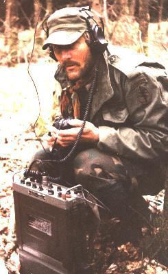
Now Al would have to put up a very long wire antenna to make an HF radio shot that would reflect off of the ionosphere above us and reach our retreat just on the other side of the mountain. This special process is known as Near Vertical Incident Skywave or NVIS. Joe and I had practiced it on a daily basis, with other like-minded ham radio operators throughout the region, for a few years now. Initially we’d had quite a few problems setting up the net, but thanks to the perseverance of a few key operators in the region, we had worked through the issues and created a very dependable network. Not only would it fill in the gaps caused by the surrounding terrain, eliminating the need for mountaintop VHF and UHF repeaters (repeaters which were all now dead due to lack of electricity), it was much harder to locate HF transmitters with direction finding (DF) equipment.
The antenna Al needed to set up would be 128′ long and would run parallel to and about 12′ above the ground with two thin wire elements, each approximately 64′ long. It is connected in the center by a short section of RG-58 coax cable which leads down to the small Elecraft KX3 HF transceiver. The radio is then connected to a tiny Winbook TW7 tablet through a very small Signalink USB modem. Everything combined is small enough to fit in a Zip-lock freezer bag. The tablet is running a free peer-to-peer communications software known as RMS Express. We had used the program extensively before WROL with an organization known as AmRON. They helped groups of preparedness minded radio operators set up nationwide and local radio nets and radio bulletin boards. Joe was still in touch with a few of them in communities scattered around the mountains. One of them was his life long friend Jack Conner. Jack’s radio had gone silent about 2 weeks ago.
Jack’s home was our destination.
Al has already encrypted the situation report (SITREP) to be sent back using the team’s “transmit” one-time-pad (OTP) that he and Al had generated with dice before the mission. Joe had the matching “receive” pad back in the radio room that he would use to decrypt or “break out” the message from the team. Joe kept another pad labeled “Transmit” back at the radio room. If Joe had a message for the team he would encrypt it using this pad. Then Al would use the teams matching “Receive” pad to decrypt the message from Joe. Using two sets of pads allowed both sides to have messages ready to send simultaneously.
If Joe had messages for the team, he would have already encrypted and then loaded them into the computer tied to his base station radio. The beauty of the system is that no one has to be at the base station radio when it is called up by the deployed team. It can be programmed to scan several frequencies until someone calls it on one of those frequencies and queries the base call sign. If the calling station has its call sign loaded in the base station computer, the base radio will automatically send all messages loaded in the computer for the calling station and then receive any messages intended for the base station. Just like the upload and download of email.
Since the FCC seemed to have gone away along with most of the FedGov, at least in our little part of the mountains, and the airwaves seemed to be mostly quiet, we tended to occasionally ignore the ham radio regulations such as no encrypted messages and using your legitimate call sign. We now generated random call signs to keep unwanted listeners from grabbing our traffic. Once the base and team call signs were used once, they were stricken from the list and not re-used. The multiple frequencies given to a deployed team that the base station monitored were also random and once one was used would not be re-used for months. These random items were listed in the Signal Operating Instructions (SOI) given to the team before it deployed.
Al followed me just outside of the RON. He had given the ICOM R-20 to Andy to monitor while we worked. The little handheld communications receiver was programmed to intercept radio transmissions near our location. Back at the cove, Al and Joe had programmed it to scan the common civilian channels: GMRS, FRS, MURS, Marine and CB. If anyone nearby keyed a radio mic using any of the bands, we could listen in as well as have a good idea of their distance from us. Al had extended the range of the scanner to a few miles by constructing a special portable antenna known as the RC-292 that we could unfold and hoist up into a tree overhead when we were in a fixed or static position.
I watched as he used his compass and map to determine the azimuth back to our cove from our current location. Once he was satisfied with the direction, we began looking for two trees that lined up on an azimuth 90 degrees out, or broadside back to the direction of the cove. He found two that were just a few feet further apart than the antenna would be when rolled out to full length.
Al unrolled two thin un-insulated antenna wires from their spools while I held the free-running ends. One of the wires was marked with small pieces of green duct tape at 5 feet intervals with the distance marked on each tab. When he had rolled each out to the 60 foot mark, he took a small, rolled up tailors tape out of the canvas antenna bag and measured out the final 4 feet of wire on each. He quickly replaced the section of bicycle tire inner tube, that had been cut to resemble a large, heavy-duty black rubber band, back around the spool, holding the remaining unused wire in place.
I laid the antenna wire on the ground between the trees then tied a section of 550 cord to the plastic insulators at each end. Using a large fishing weight tied to the other end of the para cord, I selected a low limb about 15 feet off the ground at each tree, threw a weight over the limb and then, when it fell to the ground, pulled the 550 down, and hoisted one end of the antenna up about 12 feet above the ground. I then tied the cord securely around the tree truck. Al had already connected the coax to the connector at the center of the two wires and now he pulled the other end up until the entire antenna was about 12 feet off of the ground between the trees, and then tied that end off also. He connected the radio to the other end of the coax, turned the radio and tablet on, set the freq. and gave me the thumbs up. Everything was ready.
“Send away” I said.
Al tapped at the small tablet, then knelt back on his knees, watching it closely. After about 1 minute, he said, “They got it. and there’s a message for us.”
Al handed me the tablet and started breaking down the gear. The message was in the clear and read “Expect rain later today.” I deleted the message and after shutting the tablet down, then handed it back to Al. Joe had sent the message without encrypting it since it was not mission critical. His action saved us the time required to stop to break it out, as well as saving the limited decryption pages for future messages.
While he was packing the radio and tablet, I dropped the antenna and started rolling it up. Working quickly we finished packing the radio gear and checked for anything left behind. Jim signaled “move out” by raising his support hand, open palm facing forward, to his left shoulder and then slowly let it arc forward down to his left hip. The signal was passed back and we were moving out less than 5 minutes after our radio contact.
As each man passed me, I gave them the weather info we had received and I fell into the file formation. Andy, our guy with eyes like an eagle, was on point with the compass, then Jim on pace count, Al, monitoring the scanner, and finally, me, taking up the rear. Soon were moving quietly through the thick early morning fog on azimuth along the side of the spur to our south.


[…] Read and learn. […]
[…] More… […]
Awesome writing. Really enjoying this series. I thought the idea of patrolling during the day to take advantage of temperature differences to avoid thermal detection was very interesting
TFB, Thanks for reading. The Taliban in Afghanistan realized they were vulnerable to our night vision and thermal devices when moving at night. They sometimes adapted by moving during the day in the green belts along waterways in the NE portion of the country. We’ve practiced similar techniques and had good results.
Reblogged this on LibertasIntel.
Reblogged this on The Defensive Training Group.
Dan, thanks again for continuing this series. I am a visual learner and this is the next best thing without actually making a video.(Which would be amazing). Reading textbooks, doctrine and manuals are all great, but this is by far a better way to learn some of this information. So if I am understanding things correctly our guys are communicating back to their base with an HF data radio? I have thought this would be a pretty good way to communicate too using NVIS, although I have never actually done it. I would be really interested to learn more about this setup you mention in the story, especially how to set up the automatic encrypting and decrypting and the email like setup. Thanks again for putting this up.
ST, Thanks for commenting. I am happy to provide the service. Even better than a video would be attending a class such as Mosby or Max Velocity conducts. Nothing better than having a real-world frame of reference. I will see about a seperate post regarding the equipment and setup.
I picked up a water resistant note book thru Viking Tactics made by Rite in the Rain. It has an aide memoire for troop leading procedures, so I’ll bet somewhere out there one of those kinds of pads have a brief memoire for comms procedures.
Excellent read..Getting headache, need more
[…] III […]
Let’s see. With a year to digest this chapter, some things appear. They have a tablet computer. Unless they are very good about wiping it, it will retain latent copies of files sent and received. So means must be in place to destroy it rather than let it be captured. In the same way, the one time pads must have a means of total destruction. The one time pads could be on a micro sd card. They might be easily destroyed – crushed and scattered – with little hope that any other that the most technological opponent could recover anything. Or maybe fired with an ounce of thermite. The advantages are much faster encryption and decryption – more time to move out. With the right tablet, all the memory might be on micro sd cards. One advantage, with the right (easy to code) program (much like Tom Clancy’s “Tapdance” program from his novels) the “one time pads” would have enough data to encrypt photos and large files. These pads would need to be electronically generated – not hard, even given the need for electronic real random number generators. Imagine a 2 or 4 GB micro sd card with 1000 or more 1 Meg one time pads, smaller than a postage stamp. The rest of the card could be set up for a live installation of Linux – allowing the tablet to be operated independently of Windows – all files on the micro sd card only. And it could be destroyed easier than a hard copy one time pad.